Osterley Park to Brentford
Osterley Park is one of the last country house estates within London. Pastures dotted with cows and horses surround the ornamental lakes which loop around the house. All of this was designed by Robert Adam in the late 18th century. From this peaceful scene this route runs the gamut of post 18th century industry, beginning with a canal then rail and motorway and from above the noisy intrusion by the flight path into Heathrow. The walk ends at the 18th century canal dock in Brentford, close to the site of a civil war battle, now surrounded by expensive studio flats and other desirable residences.For public transport access to Osterley Park take the Piccadilly Line to Osterley Station.
1. Turn right out of the station exit and cross the track on a footbridge, heading along an alley to Bassett Gardens. Turn right then shortly left, also along Basset Gardens.
2. At the junction with Jersey Rd. cross over into Osterley Park through a narrow gateway in a brick wall. Go diagonally right here, heading for the main driveway to the house. On reaching the driveway go left on the metalled driveway towards the house. Follow the footpath beside the main drive towards Osterley House.
3. The path curves around the edge of a lake revealing the impressive front entrance to the house, broad stone steps leading up to the portico. The house was built by the famous architect Robert Adam in around 1789 for a rich banking family. It replaced a tudor manor house which had been repossessed by the bank. The house was surrounded by tranquil estate grounds which were carved in two by the M4 motorway in the 1960s.
4. The old stable block next to the house has a cafe and toilet facilities around the side, as well as a Learning Centre. Continue your walk on the path beside the stable block, going straight ahead towards the north east.
5. The path reaches the fence separating Osterley Park from the M4 motorway. The relative peace of the grounds is shattered by an unbroken roar of traffic from one of Britains busiest roads. Follow this path for about 400m then just beyond a house on the left go through a gateway and turn right onto a track (sometimes muddy) running around the edge of the larger lake. The roar of the motorway gradually dies away.Turn left onto Windmill Lane (the footpath is on the right hand side of this road).
6. Exit from the park.
The track becomes a metalled road and then passes between two white gate houses on either side. Continue until you reach the road junction and turn left along Windmill Lane.
7. Windmill Lane.
Stay on the footpath on the RH side of Windmill Lane, a rather busy road. You shortly pass Osterley Garden Centre (which has an OK cafe) followed by a pub (Hare & Hounds) so there are more refreshment possibilities if the Osterley park tea room was closed. This short stretch of the walk is probably the least pleasant and it soon takes you under the M4.
8.Towards the Canal.
The road goes under the M4. About 200m beyond the M4 underpass there is a small layby on the right and in the corner is a narrow (possibly muddy) path between two wire fences. This crosses between a sports field and a rough pasture meadow before reaching a single track railway (the unelectrified Brentford Dock line) and a level crossing with no gates. Cross over carefully and go ahead along Trumpers Lane, through a small dreary industrial estate, to the bridge over the Grand Union canal. Join the towpath on the far side, going south.
9. The Grand Union Canal.
Take the steps on the left leading down to the towpath, turn left to go under the bridge. This is part of the Capital Ring walk. Suddenly everything is tranquil again (apart from the intermittent whine of massive aircraft coming in to land at Heathrow, a noise almost unavoidable in West London). The canal is wide and little used except by leisure boats but its original construction (as the Grand Junction Canal) began only a few years after Osterley Park was built. There are several weirs and locks between here and Brentford and an impressive iron footbridge (Gallows Bridge) which was cast in 1805 (shortly after the completion of the stretch from Brentford to Oxford). Canal and River Brent share their courses from here to the junction with the Thames so in wet weather the flow of water over the weirs is quite vigorous.
10. More Motorway Noise.The noise level rises again as you approach the motorway bridge, shortly augmented by rumbling and groaning from an aggregate and concrete works up above the canal bank. Next comes a bridge carrying the Piccadilly line tube over the canal. It looks almost elegant compared with all the other intrusions.
11. Gallows Bridge.
Cross the canal at Gallows Bridge. Ahead you can see one of several wind turbines belonging to the waste transfer station (tr = rubbish dump) beyond. Turn left to continue towards the gleaming glass HQ of the pharmaceutical giant GSK on the opposite bank.
12. Footbridge to GSK Land.
A new smart footbridge gives access to the office blocks on the other side but you should stay on the right bank, to cross under the A4, almost rural compared with its motorway cousin. There follows another lock and a huge boathouse in an advanced state of decay.
13. Brentford Dock.
Finally you reach some visitor mooring facilities and a colourful flotilla of narrow boats at Brentford Dock. Beyond is the small suburban town, famous for at least two historical battles - between English and Danes in 1016 and Royalists versus Parliamentarians in 1642 – and possibly the place where Julius Caesars forces crossed the Thames in 54BC. Where the towpath meets Brentford High Street you can turn right and cross the road for buses to Hounslow and Twickenham. For Brentford train station, with connections to Clapham Junction and Waterloo, turn left onto the High Street and turn left again into Half Acre. The station is 400m further on. Alternatively, carry on past Syon House along the Thames Path to Marble Hill House.
Total distance 9.2 km (5.8 miles).
Get Ordnance Survey maps on your website to enhance the service and customer experience.
You can download this route to your GPS or mobile phone by clicking on the 'View route..' link on the map below (provided you have registered (free) with ViewRanger
Get Ordnance Survey maps on your website to enhance the service and customer experience.
 Canal boats, with Gallows Bridge beyond
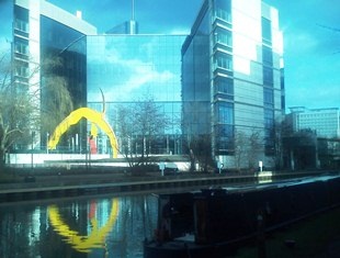 Office blocks beside the canal
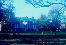 Osterley Park